
")
")

The shores of Arctic Yakutia are the “world champions” in terms of the rate of destruction.
There are a lot of people who are writing and talking about global warming, many are worried about the issues related to this topic: is it dangerous for humanity, what is happening to the climate, to the ecology of the Arctic, whether it is a natural process or the result of anthropogenic impact. And from time to time we publish opinions of scientists on this topic, because it is always important to know the scientific basis for what is happening in nature, in order to avoid false conclusions and judgments. Today's guest of our section Grigoryev Mikhail Nikolayevich, Doctor of Geological Sciences, Deputy Director of the Permafrost Institute SB RAS (Siberian branch, Russsian Academy of Sciences), Head of the Arctic Center with Scientific Research Station “Samoylovskiy Island” IPGG (Institute of Petroleum Geology and Geophysics) SB RAS (Novosibirsk)
- Hello, Mikhail Nikolaevich, let's start with a general question: what is happening with the Arctic, with the permafrost?
- Our institute has been working in the Arctic for a long time, since 1950s. In the past 30 years, annual Russian and international expeditions have been conducted to study the Arctic permafrost on the coast and the shelf of the seas of Eastern Siberia. Permafrost occupies almost the entire Russian Arctic, and this is 65% of the entire territory of Russia. The largest part is occupied by continuous permafrost, and the southern part of the cryolithozone - by discontinuous and sporadic permafrost.
Now, there is an increase in average annual temperatures of surface air both around the world and in the Arctic. It should be noted that the temperature does not increase everywhere, there are even cooling areas. For example, Antarctica. And in Russia there are sites where it became colder. But in general, in Russia, in the whole world, in the Arctic, in particular, we observe a rise in temperature. It is noted that it has become by 1 degree Celsius warmer than the average multi-year temperature. In Yakutsk a very large increase in temperature is observed, more than 2 degrees Celsius.
- What are the effects of increasing temperature? How does this affect the climate, the nature?
- Generally rising temperature is always serious. The greatest danger is not in the Arctic, but in the southern boundary of permafrost, where permafrost is warmer, with temperature of -1.5°C … -0.01°C (+29.3°F … +31.98°F). These temperatures are insufficient to maintain the stability of the permafrost in the warming climate. This can be dangerous for construction works, for normal condition of roads, buildings and structures, because these temperatures can pass freezing point not only at the upper part of the permafrost, but also reach depths of 10-15 meters (35-50 feet). And if the permafrost melts to a considerable depth, then there will be big problems with the stability of any engineering structure, built at this place. As we all know all buildings in Yakutia stand on pile foundations. The bearing capacity of these piles is achieved precisely by freezing the pile side surfaces into the ground. Such a phenomenon may happen on the southern boundaries of permafrost, and there are some examples in Western Siberia, then permafrost may disappear in certain areas. This is really dangerous. And in the Arctic, we have seen so far a slight temperature change in the upper part of the permafrost, while its depth here often reaches hundreds of meters, and thawing from above is small.

- Is permafrost the basis of our stability?
- What is permafrost? Permafrost is a permanently frozen soil. Permafrost is ground, which retains a temperature at or below the freezing point of water for two or more years. In fact, “permafrost” is not a very correct term. It's not permanent. It was not once, for example, 2 - 2.5 million years ago. The oldest permafrost appeared about 2 million years ago. It is true to say that the traces of the existence of permafrost are also observed in sediments that are tens of millions of years old.
As for the climate, it is extremely unstable on our planet. If you look at the graphs of air temperature fluctuations for thousands and millions of years, they look like comb teeth: up and down, that is, there have always been very large changes, even more than now. The stages of temperature decreases and increases are determined quite accurately now. There are scientific projects studying the paleoclimate. They study mainly the isotopic composition of ice. They bore wells, for example, where the ancient glaciers are - in Greenland, Antarctica, in Severnaya Zemlya. Samples of ice from such wells can give an answer to what the climate was like millions of years ago. And now science knows that on earth there were times when it was much colder and much warmer than now.
Nevertheless, in recent decades there has been a distinct warming of the climate.
-What are the reasons for this process? The eternal question: “Who is to blame?” Is mankind guilty?
- Now there is a dispute among scientists, whether there is a role of mankind in warming of a climate. Some believe that mankind plays an important role in warming, as man-caused emissions of carbon dioxide, methane, water vapor into the atmosphere increase, resulting in catastrophic warming. And other scientists say that this is not enough for such global changes, that the human influence is not so high, and this is a normal fluctuation that is associated with cosmic causes, with fluctuations in solar activity, etc.
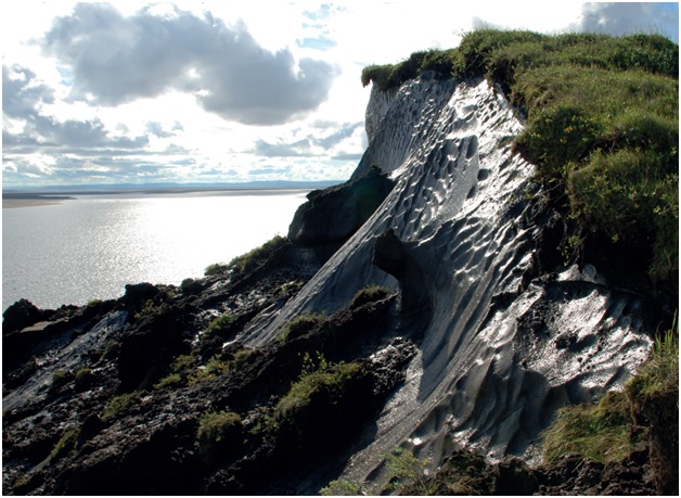
And the Arctic itself is such an area subject to the influence of exogenous processes. Exogenous processes are the result of interaction of the planet's shell with the hydrosphere and atmosphere. That is, the permafrost is exposed to external factors, for example, slope processes, water erosion, thermal destruction, the influence of sea water, sunlight and much more are particularly active during climate fluctuations. Why? The fact is that in the coastal zone of Yakutia the so-called Ice Complex is unusually widely developed. These are coverslips, mainly Late Pleistocene (10 to 100 thousand years old) sandy-loamy deposits, permeated with powerful ice veins. The origin of the Ice Complex is still debated. Most scientists agree that it is formed in conditions of predominant sedimentation, periodically abundant watering of the territory and extremely low average annual air temperatures. Millennial processes of annual frost cracking of soils and the filling of cracks with freezing moisture immediately led to the formation of ice veins (re-veined ice), the volume of which often exceeds the volume of enclosing sediments. In cut the system of veins looks like a grating. On the surface it sometimes shows up in the form of “chess” polygons - a common phenomenon in the tundra of Arctic Yakutia. The voluminous ice content of such rocks varies from 40 to 90%. They exist in central Yakutia, not so much, of course, as in the Arctic. For example, where the railway to Yakutsk is now been built, unfortunately, Ice Complex rocks lie on a large area. The builders of the railway were informed by us, we warned that it was extremely dangerous to build a railway on the “Ice Complex”. It is very difficult, almost impossible to maintain such transport systems there. But nevertheless, the railway exists, but there are and will be problems with it. Because any embankment is a dam, water will come from one side of the dam and the thawing of the “Ice Complex” will begin. Icey rocks quickly sink. Ice-bearing rocks are always very complex and unsuitable foundation for any structure, building, road or pipeline.
- Yes we, as consumers, for the best result need, that manufacturers take into account scientific research. How are your studies conducted?
- And what are we studying? In particular, we study the dynamics of the Arctic coasts, how the permafrost reacts to weather and climate changes. We have sites where we conduct observations every year. There are sites where we come every five years, there are sites, which we visit only once. We have good remote materials, these are aerial photographs and detailed maps. And now there are high-resolution satellite images. Now there is a fairly high-resolution space imagery. A half-meter accuracy satellite imagery is in open access. With the help of such remote images, repeated theodolite surveys of the shoreline or collapsing ledges, we get the exact figures how much the shore retreats on average per year. Based on the results of multi-year monitoring, we get the figures of shore destruction rates, their increases or decreases.
- What is it connected with?
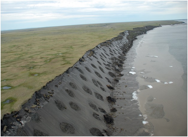
- It is connected, of course, with the climate. North of Sakha Republic is washed by the Laptev Sea and the East Siberian Sea. Under the influence of high temperatures, the shoreline collapses faster. We call this the thermodenudation of the shorelines, that is, the destruction of frozen coastal strata, mainly by thermal processes, which is accompanied by gravitational slope phenomena. In warm periods powerful slope processes begin, mainly solifluction. The earth creeps along the slope, ice is exposed and begins to melt, the streams turn into a torrent. Warm hot days in the Arctic are not rare. A very large role in the destruction of the coasts is played by sea waves. Salt water is more aggressive, it quickly destroys the sea shore with icy permafrost. And if there is a storm, then there are absolutely catastrophic destruction. A grand spectacle, when blocks measuring 20 x 20 meters fall off the shore, then the sea recycles them. And that is how the shores disappear. Part of our land is irretrievably lost. Sakha Republic loses on average 10 to 11 square kilometers of land per year! It is a huge area and so every year! And multiply these figures to 1000 years, even to 100 years! These are giant areas. Many European countries would be horrified if they lost such areas every year. For example, Holland. It would have decreased considerably due to the immersion of part of its land under the sea, and the shores are artificially built up there. Therefore, the shores of Arctic Yakutia are “world champions” in terms of the rate of destruction.
In the north of the Republic, the banks of the Holocene and Pleistocene rocks, whose age varies from 1 to 100 thousand years, are quickly destroyed. Hard rocks are destroyed slowly, by a millimeter a year, sometimes a bit faster. Pleistocene rocks, which collapse most rapidly, are very common in the north of Yakutia. Most of these rocks are represented by the Ice Complex. The Cossacks called such ice-saturated ridges “yedoma”, since the ice complex is often found in the form of ridges, between which there are thermokarst depressions, as if eating (Slavic “yed”) these ridges.
The main part of Yakutian coasts are defined as destroyable, only a small part is considered stable. In addition, there is a growth of coasts into the sea. Such areas are few within the Arctic deltas of large rivers, and even then not everywhere, usually in areas, where delta grows towards the sea or within such very shallow accumulative bays. This is a natural phenomenon. Everywhere there is always an invisible struggle between the accumulation of materials and the destruction of this material. In nature, the mountains and the coasts are destroyed. And the destroyed material accumulates in the lowlands, valleys of rivers, etc.
In summer, over the permafrost, there is a seasonally thawed layer. In Yakutsk, for example, the melted layer is from 1.5 to 3 meters (5 – 10 feet), and in the Arctic this layer is much smaller, there is a short cool summer, it is somewhere 50-70 cm (1.5 – 2.2 feet) in sands and 10-15 cm (4-6 inches) under peat or moss. Observation of the long-term dynamics of the seasonally thawed layer shows that there is no significant increase of its thickness, in spite of a slight increase in the temperature of surface air. There are many reasons why the seasonal thawed layer does not increase much: it can be the influence of vegetation, precipitation (especially the thickness of the snow cover), the peculiarities of the temperature profile in summer and winter.
The destruction of shores depends, first of all, from our point of view, on the storm activity. Powerful storms remove the destroyed material immediately from the foot of these shore ledges, create thermoabrasion niches at the base of the coastal ridges, and erode the coastal strata as a whole. Storm activity in recent decades has increased significantly due to the fact that in the summer time, the melting of the consolidated Arctic sea ice is accelerating and the area is rapidly shrinking. The larger the area of open water, the greater the dispersion of waves and, correspondingly, their size. The area of distribution of pack ice, solid ice has decreased from 7.5 million square km in 1980 (September) to 3.5 in 2012, and then began to increase slowly. What will lead to such fluctuations in the area of ice is difficult to say, but this is still the most serious response of the Arctic natural system to the warming of the climate, which is widely discussed. The website of the University of Colorado has a database on snow and pack ice. There, the graphs show the area occupied by these ice yesterday, three months ago, in the spring, in previous years.

- Is there still anthropogenic impact in this?
- The theory that humanity is to blame for the warming of the climate, that humanity releases a lot of carbon, supplementing natural emissions, is not proved! It is very difficult to calculate the actual greenhouse gas balance, because there is an ocean that absorbs and emits gases in large quantities depending on temperatures and other conditions, forests, Amazon forests, steppes emit huge amounts of carbon dioxide. In fact, I read that the steppe can give off more carbon dioxide than the forest, because here the area of all the vegetation (meaning the area of each individual blade or leaf) can be larger than the forest, although it does not look so visually. Although anthropogenic carbon emissions into the atmosphere are increasing year by year and this fact can not be neglected.
- We talked about the shores, and now - about land. What is happening there?
- In the Arctic there are a lot of gully and lake formations. There are such powerful processes ar going on here as gully erosion and lake thermokarst. If they occur in ice rocks, then, given that the climate is warming, these processes can erode the surrounding land even more rapidly. For example, such ravines can also carry a lot of ground material into rivers and seas. And this is also an important factor in the destruction of coastal plains. Ravines can be very long, deep and develop rapidly, destroying (eroding) the surrounding surfaces.
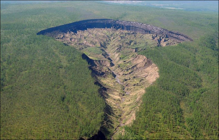
- Is it like “Batagaika crater”?
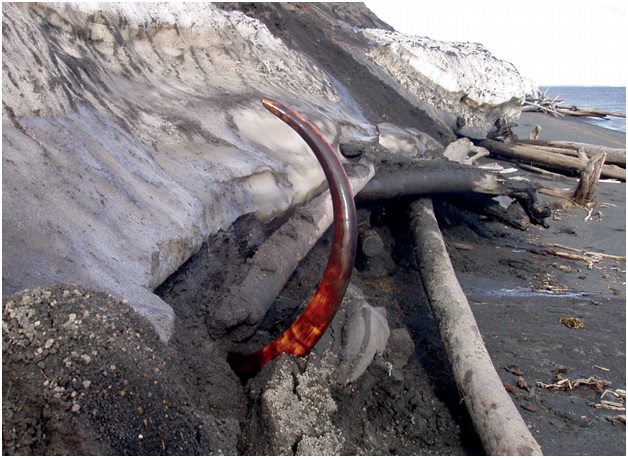
-Batagaika crater belongs to a special denudational cryogenic type of formation. It was known for a long time. A good article about this depression in Ice Complex rocks was published in Russian magazine – “Kriosfera Zemli” (“Cryosphere of the Earth” http://www.izdatgeo.ru/pdf/krio/2013-1/56.pdf ). There are different hypotheses of occurrence of this depression. But most likely it appeared in the early 1990s in connection with the activation of thermo erosion and thermokarst processes on the slope of a small mountain, and this, apparently, is also related to the warming of the climate in the last two decades. The sides of the depression have ice-bearing rocks. Approximately in 1996-2001, apparently, there was a breakthrough of water from the formed depression in the direction of the Batagayka River, not far from its confluence with Yana River. The depression is constantly being studied. This year German scientists and scientists from the Institute of Applied Ecology of the North of North-Eastern Federal University went there. The depression is only 10 km from Batagay settlement, so it is convenient for its examination by scientists, including paleontologists, who study the mammoth fauna. Incidentally, almost 90% of finds of tusks, bison bones, musk oxen, that is, mammoth (or Pleistocene) fauna, are found in such ice rocks in the north. Almost all these animals lived at the time when such a landscape was formed and such here are the ice sheets. Why did the large ancient animals prefer such landscapes? Apparently for them there was enough biomass, for example, a thick grass. And they walked from the south far to the north and back, because in the past, there were regressions and transgressions of the sea, that is, multiple downturns and rises of sea level. The sea retreated 300-500 km to the north for from the modern shore, due to the fact that during Ice Ages, ice took a lot of water from the sea. And where today we have a sea shelf, in former times was a land of mammoths, primitive hunters and even ancient cave lions. The last Ice Age was about 16-22 thousand years ago. At this time, the surface of the seas and oceans dropped about 100-120 meters below the modern level. The shelf has long been a plain, then the sea level began to gradually increase and somewhere around 5000 years ago it stabilized and became close to the modern. Transgressions and regressions of the sea have always been, but mankind, of course, does not remember it, but such events are recorded firmly in the continental and marine sediments.
"Is there permafrost under the sea?"
- Yes there is. We are also engaged in underwater permafrost. Under the sea, under the Arctic seas there is permafrost (perennial). It was formed at the time of regression, the sea retreated hundreds of kilometers from the modern coast, and for millennia the cold penetrated into the ground below with dry shelf. When the sea returned, permafrost underneath persisted for a long time, since the very Arctic sea is very cold. In many parts of the bottom, water temperature is below freezing temperature of water, since salt water does not freeze even at minus few degrees Centigrade. And there are many such places in the Arctic Ocean, on the shelf, in the Laptev Sea, in the East Siberian Sea. And the relict permafrost beneath them melts very slowly. Not just the warm sea, but also salt solutions in bottom soils may melt the permafrost, and they penetrate the bottom grounds pretty deep. Underwater permafrost degrades most rapidly near the coast, at relatively shallow areas of the shelf and its gradients surface (or roof) have the smallest bias in the sea where the coastal retreat speed is maximal, and vice versa, a very steep slope - near stable coasts. The fastest rate of degradation of the subsea permafrost roof up to 30 cm near the coast. The more sediment layer above the submarine permafrost, where its degradation becomes slower.
There are significant problems in Western Siberia due to climate warming. We have a “Batagaika crater”, the size of which is hundreds of times much larger than recently discovered explosive crater on the Yamal Peninsula. But there are a lot of craters on the Yamal. The reason for the formation of these craters may be warming. In this region for several years been an abnormally hot summer, the temperature exceeded +30°C (+86°F). Secondly, the Yamal is a land that “floats” on the gas. Once I was at a conference in Salekhard and the scheme in the Governor's residence showed, what is happening on the Yamal Peninsula, where a tremendous amount of gas fields are discovered. I had the impression that the gas was everywhere although located at great depths. And it is clear that the gas flows through cracks, fractures, along weakened zones, somewhere rises, somewhere accumulates as bubbles and a tremendous exhaust happens during record-breaking thawing of the upper part of the permafrost – and this creates Yamal craters.
- How does development of the Arctic affect the environment?
- The development of industry in any way affects the Arctic environment. Our republic occupies a huge chunk of the Arctic. Today, our Arctic is one of the least developed. Just one company operates in the Arctic – “Diamonds of Anabar”. There was a time when “Kular Zoloto”, a gold company operated here, but it has been over 25 years since it closed the business, there are little independents mines left. The company closed its business due to huge transportation costs, fuel delivery, etc. Now, in settlements there are only boiler-houses and power plants, which produce heat and electricity, utilities, and there is a seaport in Tiksi. Only a few ships navigate there, the Arctic Shipping Company went bankrupt a long time ago, we don’t have anything in our Arctic. I know that in Chukotka a Bilibino nuclear power plant is operating, supplied through Chersky, where there is a small port “Zelyony Mys” (“Green Cape”).
There might be huge hydrocarbon reserves in the Arctic shelf, a much more has to be studied. Development of the Arctic shelf may help our Arctic to recover. For example, the West Siberian Arctic: Salekhard, Urengoy, Khanty-Mansiysk. It's cities of future. Everything is modern and new. And by what means do you think there are so developed? By funds and taxes that come from the production of hydrocarbons, huge amounts of money are invested, huge buildings, airports, stadiums etc. are constructed. A lot of money is invested in the environment, cleaning island territories, and we have no money, because our northern territories are on subsidy, no profit, practically no development of production. Therefore, I think, only the activation of hydrocarbon “fields” on the shelf and in coastal areas can help the situation. There are good geological prospects. The coastal area in the Khatanga Gulf of the Laptev Sea is being bored, deep geophysics conducted in adjacent areas. Maybe somewhere I was wrong. But in general, I think, I’m right.
- Thank you very much, Mikhail Nikolayevich, for the interesting and informative conversation!